William K. M. Lau
Laboratory for Atmospheres, NASA Goddard Space Flight Center, Greenbelt, MD 20771
K. M. Kim
Morgan State University, Baltimore, MD 21251
Figure 1 a) Time series of mean surface air temperature (°K) from AIRS over West Russia {30-60° E, and 45- 65° N}. Smooth curve indicates climatology (2003-2009). Positive anomalies are shaded in red up to the time of the snapshot shown in left panels, b) Same as in a) except for time series of rainfall over northern Pakistan {70-75° E, 30-35°N}, c) snapshot of 500 hPa geopotential height (m), 200hpa wind speed (m s-1) for July 27, 2010, from MERRA analysis. The target area over northern Pakistan and regions to the west is indicated by the rectangle. The trough axis is indicated by the thick dashed line. The closed low and the tropical cyclone is labeled L and C respectively, d) same as in c) except for TRMM rainfall (mm day-1) pattern. Source: Authors. Time series of mean surface air temperature (oK) from AIRS over West Russia {30-60o E, and 45- 65o N}. Smooth curve indicates climatology (2003-2009). Positive anomalies are shaded in red up to the time of the snapshot shown in left panels, b) Same as in a) except for time series of rainfall over northern Pakistan {70-75o E, 30-35oN}, c) snapshot of 500 hPa geopotential height (m), 200hpa wind speed (m s-1) for July 27, 2010, from MERRA analysis. The target area over northern Pakistan and regions to the west is indicated by the rectangle. The trough axis is indicated by the thick dashed line. The closed low and the tropical cyclone is labeled L and C respectively, d) same as in c) except for TRMM rainfall (mm day-1) pattern.")
The catastrophic societal impacts caused by the 2010 summer Russian heat wave and Pakistan flood have attracted much media attention and spurred many scientific investigations on these topics. Ongoing studies have found that the immediate cause of the Russian heat wave was an atmospheric blocking event, which metastasized into a severe heat wave with raging forest fires over vast regions of western Siberia [1;2]. On the other hand, the Pakistan flood was attributed to unusual atmospheric events in the tropics, shifting deep convection from the Bay of Bengal to northern Pakistan [3;4]. A recent study [5] has found evidence suggesting that the Pakistan heavy rain was triggered by Rossby waves generated by a blocking high associated with the Russian heat wave. Such a connection would have direct implications regarding the predictability and possible mitigation measures if similar events were to occur again in the future. In this article, we provide further evidence of such a linkage.
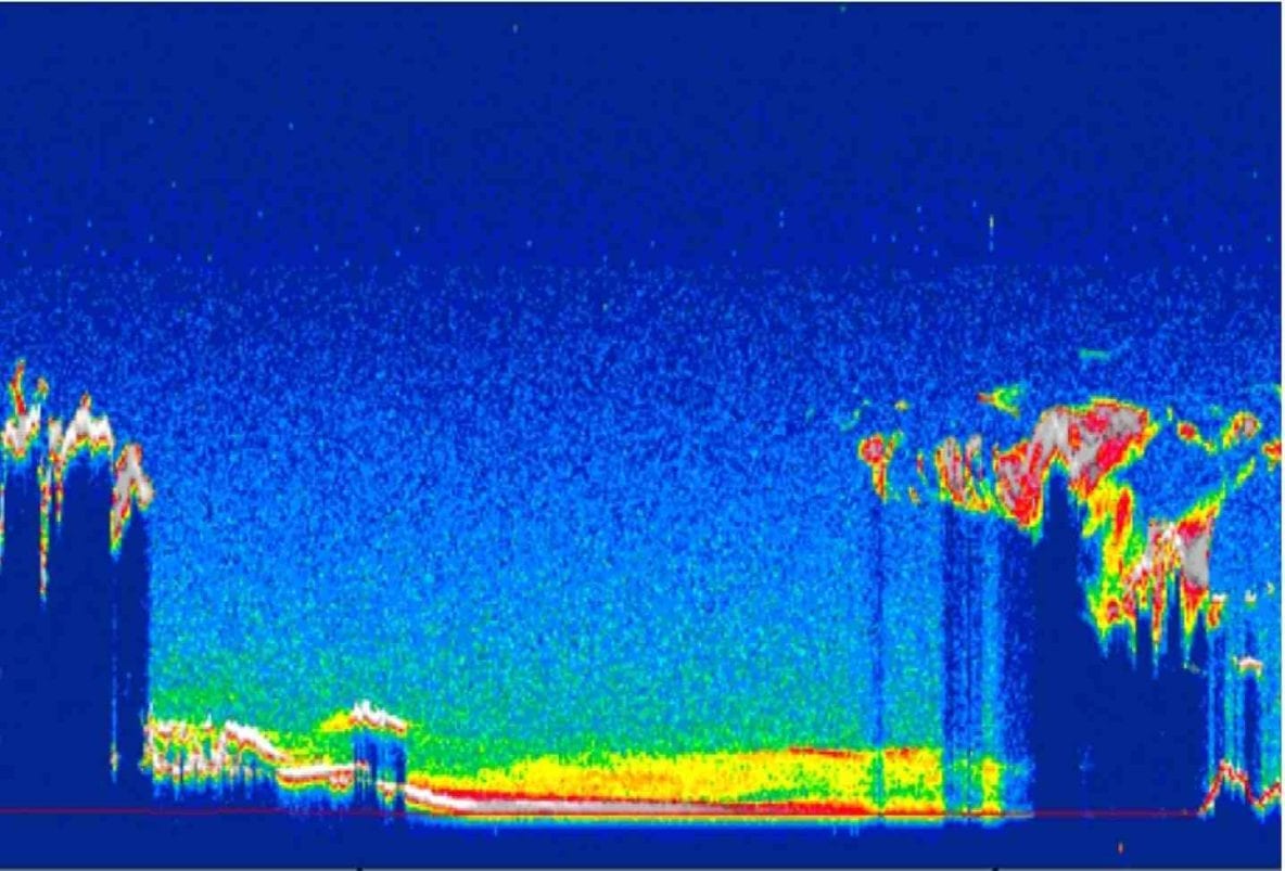
Figure 2. a) Time-latitude section of 200 hPa vorticity (10 -5 s-1) averaged over the longitude 60-70E. Positive (negative) values are shaded red (blue). Slanting straight lines with arrows indicate southward propagation speed of 5 m s-1. b) Time series of rainfall (mm day-1) over northern Pakistan. Episodic rain events are labeled from one to five. Source: Authors. Time-latitude section of 200 hPa vorticity (10 -5 s-1) averaged over the longitude 60-70E. Positive (negative) values are shaded red (blue). Slanting straight lines with arrows indicate southward propagation speed of 5 m s-1. b) Time series of rainfall (mm day-1) over northern Pakistan. Episodic rain events are labeled from one to five. Source: Authors.")
First, the two events occurred at almost the same time. The surface air temperature averaged over vast regions of West Russia began to rise above normal in mid-June and continued to grow in July through mid-August (Fig. 1a). The heat wave intensified rapidly in July 19, reaching a new high, approximately 8-9 C above normal in late July through Aug. 10. The maximum surface air temperature at Moscow (55.75N, 37.60E) reached a record high of 40o C. Meanwhile, heavy rain events occurred sporadically with increasing intensity starting on July 4-5, July 11-13, July 20-22, and July 27-29, followed by steady heavy rain through mid-August (Fig. 1b). The cumulative effects of the episodic heavy rain and the steady rain events were ultimately responsible for the heavy flooding of the entire Indus River basin, causing one-fifth of Pakistan to be submerged. During the 2-week period, July 25- Aug. 8, total rain of approximately 500 mm fell in about 10 days in the northern Pakistan Swat Valley. This represents approximately 300% of the climatological rainfall total over the same region in July-August, which is typically the wettest month in northern Pakistan. The heaviest rain occurred in July 28-29, almost contemporaneously with the maximum surface temperature in West Russia.
As shown in previous studies, a blocking high at 500 hPa was found in association with the development of the heat wave. On July 27, a day before the heaviest rain fell over northern Pakistan, the 500 hPa flow developed a characteristic Ω-block high pattern, with a deep trough (indicated by thick dotted line in Fig. 1c) and a closed low (labeled L in Fig. 1c) ahead and east of the high. The trough extended southwestward over the target region (marked as rectangle in Fig. 1c) in northern Pakistan and Iran. The 500 hPa flow was accompanied by a wavy jet stream at 200 hPa, with strong acceleration north and northeast of northern Pakistan. Near the jet entrance region, strong upper level divergence and mid-tropospheric ascent (not shown) was found, in conjunction with the presence of heavy precipitation in the eastern portion of the target region. In the tropics, a closed low (label C) with heavy precipitation formed over northeast Arabian Sea, off the coast of northwestern India. Over the next two days, the upper level trough merged with the tropical low to form a quasi-stationary, mid-tropospheric cyclone west of northern Pakistan. The vertical motion associated with this cyclone was mostly responsible for the heavy rain over northern Pakistan from July 27 through mid-August (for more details see [5]). Details of the daily evolution of surface temperature, northern Pakistan rainfall, 500 hPa height and vorticity, 200 hPa jetstream, and contemporaneous rainfall pattern for the period July 1 through Aug. 16, can be seen in the video below.
Figure 2 shows the time-latitude section of the 500 hPa vorticity perturbations across the longitude sector 60-70o E, and the northern Pakistan rainfall time series at [70-75° E, 30-40° N]. The timing of the southward penetrating vorticity perturbations (represented by the arrows in Fig. 2a), and that of the Pakistan rainfall events (numbered 1-5, in Fig. 2b ) are indicated. The extratropical vorticity perturbations originating from the leading trough of the Rossby wavetrain propagated southward at an estimated speed of approximately 5 m s-1 (indicated by slanting straight arrows). Most strikingly in Fig. 2, is the one-to-one correspondence between arrival of the mid-tropospheric vorticity perturbation south of 40° N and the occurrence of the episodic rain event. Five major rainfall events (labeled 1 through 5) can be traced back to a vorticity source near 55-65° N, 1-2 days earlier. The last triggered rain events (event # 5, around July 27-29) appeared to usher in steady moderate-to-heavy rains over northern Pakistan. As indicated in a recent study [5], the July 27-29 event and the steady rain regime were timed to the arrival of the northward propagating monsoon intraseasonal oscillation over the Indian subcontinent, which transported abundant moisture from the Bay of Bengal and the northern Arabian Sea, feeding the Pakistan heavy rain.
The above results and other current studies have provided strong evidence that there were physical connections linking the Russian heat wave and Pakistan flood. The connections involved an alignment of possible large-scale control factors such as possible initial abnormally drier Eurasian continent, an extratropical atmospheric state conducive to more and stronger Eurasian blocking, a La Nina condition in the tropics, and timing with respect to the northward propagating intraseasonal oscillation. Future research, including numerical modeling are needed to untangle the relative roles of each of the control factors, and underlying local feedback to provide a better understanding of these historical events.
References
[1] Matsueda, M., ÛÏPredictability of Euro-Russian blocking in summer of 2010Û, Geophy. Res. Lett., 38, L06801, 2011, doi:10.1029/2010GL046557. [2] Dole, R., M. Hoerling, J. Perlwitz, J. Eischeid, P. Pegion, T. Zhang, X-W Quan, T. Xu, and D. Murray, ÛÏWas there a basis for anticipating the 2010 Russian heat wave?Û, Geophys. Res. Lett., 38, L06702, 2011, doi:10.1029/2010GL046582. [3] Houze, J.A., K. L. Rasmussen, S. Medina, S. R. Brodzik, and U. Romatschke, ÛÏAnomalous atmospheric events leading to the 2010 floods in PakistanÛ, Bull. Amer. Meteor. Soc., 92, 2011, 291ÛÒ298. doi: 10.1175/2010BAMS3173.1 [4] Webster, P. J., V. E. Toma, and H.-M. Kim, ÛÏWere the 2010 Pakistan floods predictable?Û, Geophys. Res. Lett., 38, L04806, 2011, doi:10.1029/2010GL046346. [5] Lau, K.-M., and K.-M. Kim, ÛÏThe 2010 Pakistan flood and Russian heat wave: Teleconnection of hydrometeorologic extremesÛ, J. Hydrometeor., 2011, submitted.ÛÄ
William K. M. Lau is the Chief of the Laboratory for Atmospheres, NASA Goddard Space Flight Center. His research expertise include monsoon dynamics, precipitation processes, intraseasonal and interannual variabilty, aerosol-climate interaction, and climate change.
Kyu-Myong Kim is an associate research scientist at the Goddard Earth Science Technology and Research Studies (GESTAR), Morgan State University. His research expertise is in climate diagnostics, atmospheric water cycle, remote sensing data analysis, and climate modeling.