
Experts agree the Pacific Northwest is likely to experience a Cascadia Subduction Zone earthquake at any point in the next 50 years. The event will be catastrophic, directly impacting the lives of 13 million people from British Columbia to Northern California.

The Pacific Northwest is preparing for a major earthquake and the tsunami that will follow. Image Credit: Jenny Woodman
On one particular crisp autumn morning in October, nothing happened. There were no announcements; there was no hoopla and no alarms sounded. In Portland State University’s åÊgeology department lounge, a couple of students were quietly working on computers, mapping landslides using complicated Geographic Information System software. In the large, auditorium-style lecture hall around the corner, the professor spoke as students diligently took notes, oblivious to anything other than their subject.
Outside, students crisscrossed the paths on a dry and sunny day in Portland, kicking up leaves as they trudged onward to their first class, their last class, to whatever errands needed doing. While it was an ordinary day on Portland State’s campus, elsewhere along the West Coast, as part of the annual Great ShakeOut, more than 270,000 people in Oregon, Washington, and California dropped, took cover, and held on to simulate what people should do during an earthquake, and imagined what life would look like during and after an event that would change their lives forever.
The shaking could last for up to five minutes.
Bridges, roads, and buildings will crumble; schools and businesses will be closed indefinitely. Vital infrastructure – power, water, sewage, and phone lines — will be down for months, perhaps even years. The Interstate 5 corridor will be devastated, wreaking havoc on supply chains; food, medical and other critical resources will be difficult to distribute throughout the region. A Cascadia Subduction Zone earthquake will directly impact the lives of more than 13 million people from British Columbia to northern California.

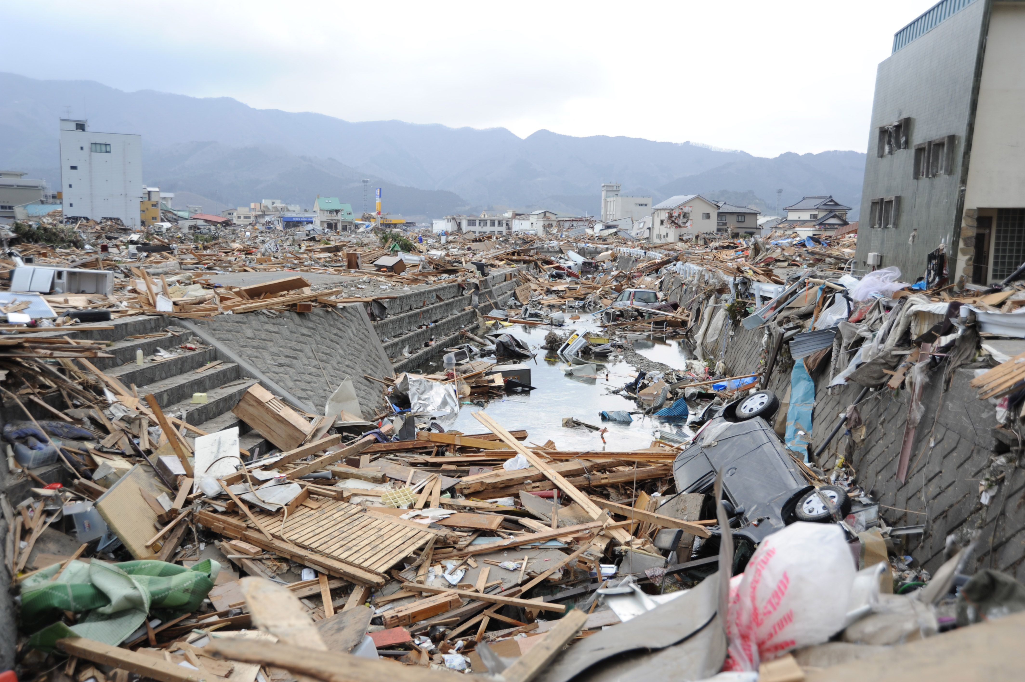
The 2011 Tohuku earthquake was magnitude 9.0 undersea subduction zone, or megathrust, earthquake similar to what is expected in the Pacific Northwest. Image Credit: Wikipedia Commons
The region has experienced many major earthquakes but none have occurred in the nation’s recorded history. The last major earthquake occurred on Jan. 26, 1700, but it wasn’t until the 1980s that scientists learned of the event by traveling to Japan and looking through records. They found an ÛÏorphanÛ tsunami with no earthquake, meaning that the tsunami was most likely generated by seismic activity across the Pacific Ocean. Today, many scientists, like Portland State Geology Professor Emeritus Scott Burns, agree that there is a strong likelihood that the Pacific Northwest will experience a major earthquake of a magnitude eight or greater at any moment in the next 50 years.
This type of earthquake will be unlike anything experienced in U.S. history, and many people in the region are unprepared to deal with an earthquake of this magnitude. Since 9/11 and Hurricane Katrina, federal, state, and local governments have focused considerable efforts on the task of preparing communities and regions for natural and man-made disasters. Since there is little time to maneuver during a large-scale disaster, experts from the Federal Emergency Management Agency (FEMA) and the American Red Cross suggest that it is important that people take the appropriate steps before they strike to protect their property, belongings, and, most importantly, lives.

U.S. Geological Survey map shows where plates converge, creating a subduction zone, which generates volcanism and earthquakes. Image Credit: USGS
Burns explains, ÛÏPeople are interested; what does it mean for me? Û_ Everybody needs to know that this is earthquake country.Û
Burns, who has been teaching for more than 45 years, is an authority on natural hazards. Earthquakes, landslides, floods, coastal erosion, radon poisoning, and volcanoes all fall under the umbrella of his expertise. Although he also has written quite a bit about soil and winemaking in Oregon, Switzerland, and Chile, scanning his voluminous list of disaster-related published works, it would be easy to imagine him as a rather gloomy fellow, but he is, in fact, quite the opposite.
Burns is upbeat and enthused as he explains, ÛÏWe’ve come along way. What we need to do is work with individuals. Get all the homes ready; make sure they have enough water as a backup, strap down their water heater, know how turn off valves for the gas, and things of that nature.Û
Burns adds that the average citizen doesn’t know that they’re going to need one gallon of water per person for each day before help arrives. They don’t know that it could take a week, maybe longer, for any substantive aid to start pouring into the region. So, they’ll need to have food, backup prescriptions, flashlights, and battery-operated radios. Most importantly, people are going to have to get to know their neighbors because, in the early hours and days of disasters, friends and neighbors, not first responders, are the ones doing search and rescue operations.
The shelves along the back wall of Burns’ office are overflowing with rocks ÛÒ garnierite, andesite, grandodiorite ÛÒ dusty samples of what makes the Pacific Northwest one of the more interesting geological places to live. Evidence of decades of teaching and scholarship are crammed into his tiny room. It looks as if he ran out of shelf space for his library sometime in the early Û÷80s; books are stacked six feet high in every corner, under the desk, and on every available surface.
Every inch of wall space not dedicated to books and rocks is filled with colorful images of volcanoes. Mt. Hood and Mt. St. Helens are familiar and comforting parts of the local landscape, so it is all too easy to forget that these mountains also are signposts marking the violent processes that have created this place. The irony of the fact that this room would be a very dangerous place to be if an earthquake happened is not lost on him. He points to a tiny space under his desk, barely enough room for a small child to take shelter ÛÒ ÛÏI’ll duck, cover, and hold right there,Û he says with a laugh.

Rock samples line the shelves of Burns’s office. Image Credit: Jenny Woodman
But it isn’t always easy to get people to take action. One 2012 FEMA report suggests that preparedness levels are improving, thanks to increased public awareness. Approximately half of participants reported having emergency plans and supplies ready.
ÛÏOur preparedness has greatly increased,Û Burns explains. ÛÏWe’re ready ÛÒ emergency managers, hospitals, police ÛÒ they all know what to do now. We have a lot of organizing left to do at the local level, but in the big picture we are a lot more prepared than we were 20 years ago. Û
According to Burns, it wasn’t until 1994 that people even knew that it was possible for an earthquake to happen here. There weren’t appropriate seismic building codes, no plans in place, and no awareness among the general public.
However, he adds that the region still has a long way to go. Today, 90 percent of the region’s fuel is housed along a river at the northern edge of the city. Tank farms extend for six miles along the Willamette River adjacent to Portland; most of the area was built before there were any seismic codes. The soils along the river are expected to react poorly if there is a large quake; this behavior is called liquefaction, where the soils lose strength and behave as a fluid.
Yumei Wang is a geophysicist for Oregon’s Department Geology of Mineral Industries. In 2015, she told Oregon Public Broadcasting (OPB), ÛÏThe risk here is extreme, within 10, 20 seconds (of shaking), the sand will turn into a thick, sandyåÊsoup.Û Wang added that she can’t imagine a worse place to build energy infrastructure.
ÛÏThere are 10 tank farms lined up there, one after the other after the other, all being fed by one pipeline,Û Burns said. ÛÏThese guys, they aren’t budging. The tank farm guys say it’s very expensive to move that stuff around and when we tell them they’re going to have to they say, Û÷Well ÛÒ we’re going to have to take our chances.’Û
Representatives from Phillips 66 and Kinder Morgan noted that their respective organizations have met all legal requirements for construction, repair, and disaster preparedness. Melissa Ruiz, corporate communications manager for Kinder Morgan said via email, ÛÏWe have not performed any seismic retrofit work on existing storage tanks due to grandfathering clauses, but the four new tanks in Portland have been built to the latest seismic code requirements.Û
Of Kinder Morgan’s active grandfathered tanks, there are about 24; the tanks were built between 1915 and 1964, according to a map generated by OPB. The tanks are used to store jet, aviation, gasoline, diesel, and ethanol fuels as well as additives and stormwater. The four new tanks Ruiz mentioned were constructed in 2012.
But, if someone like Burns, with all the hard and scary facts, can remain hopeful perhaps there’s reason for optimism. In an email to geology students, he wrote ÛÏEvery year in Oregon we have a simulation of Û÷The Big One’ earthquake so emergency managers and workers can practice what to do in case of a large earthquake. TomorrowÛ_ there will be a simulated quake! Remember to duck, cover and hold!Û
When asked if he thought students would actually drop, cover, and hold for the drill, he laughed and said with a grin, ÛÏNo, but maybe they’ll know what to do when it does happen.Û
See also: åÊPreparing the Pacific Northwest for an Unprecedented Tsunami here.
Jenny Woodman is a science writer and Writing Club coordinator for IEEE Earthzine. Follow her on Twitter @JennyWoodman.